canyonwalker: wiseguy (Default)
One thing that's missing from my post earlier today about the 103° weather is moaning about how hot it is. But that's because I'm not moaning. I had it easy today with an indoors job, working from home, with good AC in my house. I left the AC running all night and through the morning, which was good because by 10am it was already in the 80s outside.

I haven't always had it easy with summertime heat, though. When I grew up in Virginia, near Washington DC, we didn't have AC. ...Well actually we physically had AC, but my parents stubbornly refused to use it in all but the worst heat.
Heat + Humidity = Awful

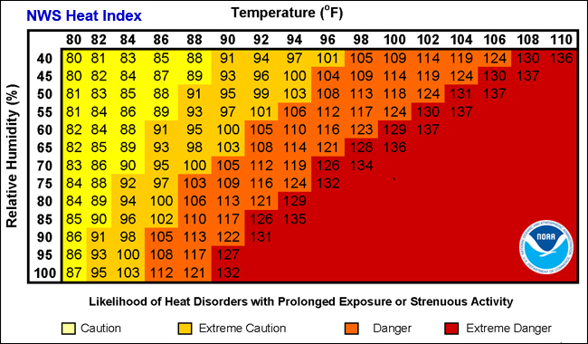
Worst heat, BTW, wasn't 103° like we had here today. The temps there rarely broke the three digit barrier. But it felt way worse because of the humidity. There's a concept known as the heat index. This chart from the National Weather Service shows what it feels like (i.e., the effect on the human body) when high temperatures combine with high relative humidity:

NWS Heat Index

As you can see in the chart, an air temperature of just 90° combined with 85% relative humidity (common in the area where I grew up) produces a heat effect on the body equivalent to 117° in low humidity. That's what everyone means, whether they know it or not, when they quip about Phoenix or Las Vegas, "Oh, but it's a dry heat!"

"But it's a dry heat!"

I experienced a funny little A-B test on this when I moved out to California years ago. We were driving cross country for 8 days. On the last day we started in Elko, Nevada, in the high desert where the air was cool. In the afternoon we drove through Northern California during what we later discovered was a record setting heat wave.

I stopped for gas around 3pm in Sacramento. I was dressed in trousers because they were appropriate for the weather where I started the day 400 miles away. It was hot out there, but not worse than what I was accustomed to as summer weather. "It feels like 90 out here," I remarked to Hawk.

Moments later we saw a thermometer sign at a bank down the street proclaiming 114°.

114°... But it's a dry heat!


Update: Keep reading in No AC on Memory Lane
canyonwalker: Planes, Trains, and Automobiles. Travel! (planes trains and automobiles)
This evening we left town on a long weekend vacation. Hawk has Monday off for Juneteenth, and I took a day of PTO so we could make a three-day weekend trip in the warm summer weather (cough, cough, surprisingly cold today).

We often begin these trips with Friday Night Halfway, a technique of driving for a few hours Friday evening and another few Saturday morning to make the travel more comfortable, but tonight we've gone All The Way. We're bedding down in Lee Vining, California, at the eastern foot of the Sierra Nevada mountains, 230 miles from home. It's 1:30am Saturday already.

Here are a few notes about the trip this evening:

6:25pm, Leaving home: Woohoo, the trip is afoot! ...Actually it's not a foot, it's a car trip. 🤣 Though the point of it is to get some time on foot in the Eastern Sierra the next three days. We wanted to leave a smidge earlier but we had to pack after work, having not had the time/energy to do it last night. We've both had a lot of long workdays this week.

7:50pm, Tracy: Tracy is a shitty little town/ex-urb on the edge of the Central Valley. 1980s pop stars who failed to manage their riches well live here. We're not here to hit up M.C. Hammer for an autograph, though; we're stopping for dinner.

8:50pm, Manteca: We've stopped for gas at this small town in the middle of the Central Valley. Yes, the name means lard in Spanish. Guess what they do here. It costs $110 to fill the tank on our SUV. ...And that's with the cheapest gas in the area, at Costco, $5.899/gal.

9:30pm, Oakdale: Another small town in the Central Valley. We think of it fondly as we've made many Friday Night Halfway stops here on the way to Yosemite. Tonight, though, we're going all the way... and this isn't even the halfway point. We stop in Oakdale for ice cream at Coldstone.

East of Oakdale is a decision point. We can turn one way to cross the mountains via the Tioga Pass; or another to cross the Sonora Pass. All afternoon and evening both Google Maps and Apple Maps have been routing us over the Sonora Pass instead of the Tioga Pass. It's a longer route.

While waiting in line for ice cream we check our maps again.We try forcing them to give us a driving time via Tioga; they won't. We figure they've got to be marking some kind of closure or obstacle in Yosemite. Indeed, as we zoom in, we see they're marking a closure in Tuolumne Meadow. There's a bridge out, apparently. Except we don't believe it. Yosemite's web page says nothing about a road closure. The state highway status page shows no closure. We even call Yosemite's recorded-info hotline; no closure. Electronic road signs on Highway 120 displaying traveler information about Yosemite say nothing about a road closure. Basically everyone but Google and Apple says Highway 120 is clear. We decide to take our chances.

11pm, Yosemite: Yes, Yosemite National Park. We're driving through Yosemite National Park. At night.

11:12pm, Crane Flat: Not long after entering the park we reach Crane Flat, elev. 6,192'. This is the highest I've been on land in 9 months. And there's still over 3,000 more to go!

11:50pm, Olmstead Point: During the daytime this is the place where amazing views open up on the Tioga Pass road driving east. To the west you can see the famous Half Dome in the distance and Cloud's Rest at nearly 10,000'. To the east is beautiful Tenaya Lake. We pull over in the empty parking lot and hop out to see what we can see. We can't see anything. Well, we can see the stars in the sky; that's it. The moon's not up over the Sierra Crest to light the landscape below. And it's cold out here.

Midnight, Tenaya Lake: "PAVEMENT ENDS" a sign states. LOLWUT? Apparently the park and/or the state have decided this summer is a great time to grind up 8 miles of HIghway 120 in Yosemite's high country. The road is compacted dirt and gravel for the next several miles. It'll take more than that to slow our roll, though. We're in a capable 4x4. As we climb the next hill toward Tioga Pass I see a gray wolf dart across the dirt road.

12:20am, Tioga Pass: We top out the Tioga Pass at 9,945'. This is the highest I've been on land in nearly 4 years. From here it's all downhill. Literally downhill. We're at nearly 10,000', and from here it's an epic drive down the steep Eastern face of the Sierra Sevada mountains. But we won't see it this trip since it's night.

12:40am, Lee Vining: Wow, the drive down from the Tioga Pass was faster than we expected. I guess that's the benefit of doing it in the dark; there's no temptation to go slow or stop to see things, because you can't see things. 🤣 We check into a hotel for the night. "Check in" is a rather grand term, though, as all we did was reach in the mailbox and grab the envelope with our name on it and keys inside. The family that runs this small hotel went to bed hours ago. For us, though, we'll be up for at least another hour.


canyonwalker: My old '98 M3 convertible (road trip!)
Oakhurst, CA. Sat, 14 May 2022, 10:30am.

Over the past several years we've done a lot of "Friday Night Halfway" trips. ...Well, actually not so many in the past two years due to... *gestures broadly at everything*... In the past 12 months I've only used my moniker for it, Whoa, we're halfway there, twice. Once was for an actual trip, the other was to joke about Jon Bon Jovi turning 60. He's the writer and performer of the song that line comes from, "Livin' on a Prayer". Or as we'll have to sing it in a few years, "Livin' on Medicare".

Anyway, Friday Night Halfway. It's on my mind because this weekend we're taking a trip for which I considered doing a Friday Night Halfway— driving a few hours Friday night to split the driving so we could have more time for hiking Saturday and also not get home so late. But we decided instead we'd go all the way on Saturday.

Our plan for the day is to hike along Lewis Creek in the Sierra National Forest. It's south of Yosemite National Park and just north of the small town of Oakhurst, CA. There are a few waterfalls there.

As we plotted out the drive we realized we could do it all in one day. One long day. And we'd have to leave early.

We set our alarms for 6am Saturday. We were up by 6:20. We skipped showering, knowing we were going to get dirty anyway and would shower after coming home. We packed our hiking gear, grabbed breakfast that could be finished in the car, and rolled out of the garage at 6:50am. My aim was "Leave no later than 7am" so we were already on plan!

The morning air was cool, still in the 50s, as we started heading south on US-101. We had the top down in the convertible anyway to enjoy the fresh air. We cranked up the heat to compensate. It was a bit like our morning roadtrip to The Pinnacles 3 weeks ago except a) this trip we left earlier and b) we turned off US-101 at Gilroy to head east through the mountain pass on CA-152.

Soon enough we were blasting through the Central Valley, passing through the small town of Los Banos and then the even smaller town of Chowchilla. The map above shows a slightly different route than going through Chowchilla; I have a favorite drive through the Sierra Nevada foothills to/from Oakhurst that traverses country roads through more remote areas.

A hair over 3 hours after leaving home we arrived in Oakhurst. The only stops we'd made were for red lights and stop signs. It was nearly 10am. Time for brunch!

So that's where we are now. In Oakhust. Having brunch. At a Jack in the Box fast food restaurant, because that's how we roll. 😂 Seriously, fuck expensive fancy-ass hipster brunches. We'll take comfort food every time. Today's comfort food was chicken pitas, fries, and— ooh!— a bucket of 15 Tiny Tacos for $3! 😋

Update: Next up, Hiking the Lewis Creek Trail!


canyonwalker: Planes, Trains, and Automobiles. Travel! (planes trains and automobiles)
High Desert Weekend Trip-log #13
Back Home - Sun, 27 Mar, 2002. 11pm

We got home from our weekend road trip to California's high desert tonight around 10:15pm, 52 hours after we left. For a 52 hour trip it's impressive that I've written 13 blogs. That's a blog every 4 hours... including the hours I was asleep! 😅 The rate isn't really surprising, though, as when there's something fun and beautiful to do, I can write a lot about it. Five of these 13 blogs are about visiting Red Rock Canyon State Park, and we only spent 4-5 hours total there.

This final blog covers 8 hours of the trip. Those 8 hours were our drive home from the park. BTW that drive could have been faster than 8 hours, but we took a longer route & made several stops because... Let's Go Shopping!

Leaving from the park we made our first stop less than an hour later in Tehachapi. Tehachapi is a small town nestled high in the Tehachapi Mountains, in the pass between the Mojave Desert and the San Joaquin Valley. The small downtown is being revitalized to look like the old train station that used to be the remote town's main business. Today, though, we were only stopping for lunch.

Next up we stopped in Bakersfield. This was purely a shopping stop as we trolled a TJX discount store for more of those plates and bowls we've replaced our dinnerware set with. They didn't have any, so we got the hell out of Dodge. It's like the city motto is printed right on the signs: "Now leaving Bakersfield".

Bakersfield is where we faced a decision, though. If we drove north up Route 99 we could visit 2-3 more stores for shopping. But it would add time and distance compared to the fastest route home, crossing over to Interstate 5. We chose More Driving, More Shopping.

Our next stop was in Visalia. What can I say about Visalia? Yup, it's there. And their TJX store didn't have what we were looking for, either.

Our last major stop on the way home was in Fresno. Fresno has grown, surprisingly, into California's 5th largest city. With a population of 545,000 it has surpassed Oakland and the state's capital, Sacramento.

It's not just the city of Fresno that has grown. The metro area now tops 1 million. We shopped a TJX store in the city's fast growing northwest suburbs. Seriously, last time I was in this area (several years ago) it was farms. Now it's all shopping malls.

In Fresno we wrapped up the "Let's go shopping!" portion of our trip. Once again, we left empty-handed. Our next step to complete our dinnerware set will be to buy a few more pieces from eBay sellers at eye-wateringly high prices.

From Fresno it was still a few hours home. We made two more brief stops along the way, for gas and dinner. Thankfully traffic on the Sunday night return into the Bay Area was reasonable. We encountered minimal delays in the usual bottlenecks around Gilroy. We pulled into our own garage at about 10:15pm.

Total mileage for the day: 450 miles, including the drive to & around Red Rock Canyon.

Total mileage for the trip: 890 miles.

canyonwalker: My old '98 M3 convertible (cars)
High Desert Weekend Trip-log #3
Grapevine, CA - Sat, 26 Mar 2022, 9:30am

🎵 I bet you're wondering how I knew
About your plans to make me blue
With some other guy that you knew before
Between the two of us guys you know I loved you more
It took me by surprise I must say
When I found out the other day
Oo-ooh, I heard it through the grapevine 🎵

...Haha, no, not that grapevine. Instead, not long after leaving Bakersfield and continuing our drive south in California, we've reached "The Grapevine".

Approaching 'The Grapevine' in California (Mar 2022)

"The Grapevine" is a popular if also inaccurate name for a steep mountain grade along Interstate 5 where the road quickly ascends from the flat San Joaquin Valley into the Tehachapi Mountains. In the course of only 10 miles it climbs from near sea level to over 4,000' at the Tejon Pass.

I mention that "The Grapevine" is an inaccurate name. The mountains are the Tehachapi, the pass is the Tejon.... Grapevine is actually the name of a tiny, tiny town, little more than just a dot on a map, at the base of the mountains. But because that roadsign that says Grapevine— the one you can see in the picture— is the only indicator there, millions of Californians for generations have come to know these mountains as The Grapevine.

Why does it matter what these mountains are called? From a perspective of naming, it doesn't matter a lot. Place names change as new people rename them. Often a place is known by 2 or more names at the same time. The mountain's the mountain whether you call it Tehachapi, Tejon, The Grapevine, or Shirley.

But whether you call it Tehachapi, Tejon, The Grapevine, or Shirley (don't call it Shirley), it's an important landmark for millions of Californians and visitors. The Grapevine is not just an inspiring sight, especially now early in the Spring with green grass covering its flanks and riots of wildflowers clinging to the canyon walls higher up, but also a geographical and cultural boundary. North of the Grapevine you're in the Central Valley. Once in the Grapevine, and especially once south of the first pass, you're in Southern California.

Up next: Poppies!

canyonwalker: My other car is a pair of hiking boots (in beauty I walk)
Saturday afternoon we hiked at Mt. Diablo. It was already mid-afternoon by the time we reached the trailhead just below the peak. The late-ish hour was a result of us not leaving home until after lunch and then driving to a more distant park entrance. The unexpected detour was totally worth it.

Although Mt. Diablo is one of the highest peaks in the Bay Area, 3,849' (1,173 m), a paved road goes all the way to the top. We stopped just short of the top, maybe 100-150 vertical feet below it, where there's a trail that loops around the summit. It's one of our favorite hikes in the park. "Favorite" is a relative term, though, as we've only hiked this trail twice before, and once was cut short due to snow. Our one previous full hike up here, we hiked this trail 5 years ago.

Views from near the top of Mt. Diablo (Feb 2022)

We set off going clockwise around the trail below the summit. Views to the north of Mt. Diablo open up almost right away. In the picture above you see Eagle Peak, elev. 2,369'. Beyond it, in the distance, the waterway you see is the Carquinez Straight. Further off to the left (west) it opens into the San Francisco Bay. Off screen to the right (east) is the Delta, where the waters of the mighty Sacramento River and San Joaquin River meet.

North Peak seen from near the top of Mt. Diablo (Feb 2022)

As we work our way clockwise around the summit the views shift to bring North Peak, elev. 3,557', into focus. North Peak is only a few hundred feet shorter than Mt. Diablo. Shorter is shorter, though. That's why North Peak has a dull name and no visit center atop it, just a bunch of commercial antennas.

The view here is to the northeast, out across the Delta. Geographically, this is where the Bay Area gives over to the Central Valley.

Views from near the summit of Mt. Diablo (Feb 2022)

As nice as these views are they also constantly reminded us of the dirt and haze in the air. It was like this last weekend when we hiked in the area. Back then I thought it would blow out to sea as part of California's "breathe in, breathe out" weather pattern. Well, it's still here. And the impact is that from a viewpoint like the one above it's hard to see more than 10-15 miles before things get lost in the haze. On a clearer day, looking east and northeast across the Delta and the Central Valley, you can see 100+ miles from here.

In writing about various peak hikes I've lamented that the one big drawback to hiking to a summit is that you can't really see the mountain you're climbing. The iconic view is under your feet! That's why all the pictures I've shared so far have been views other than Mt. Diablo itself. But here's where taking the trail just below the summit really pays off: we can see the summit!

Mt. Diablo summit towers over the Tri-Valley Area in the distance (Feb 2022)

This is also where we chose to change direction a little bit from our previous visit. Five years ago we continued the loop trail around the summit. You can see it contouring around the left. This weekend we decided to go up over the top, following an unmarked but obvious foot trail up the steep remainder of the slope to the lookout tower at the top. Off in the distance, BTW, is the Tri-Valley Area, home to cities such as Pleasanton, Dublin, Livermore, San Ramon, and Danville.

Updatekeep reading in part 2!

canyonwalker: My old '98 M3 convertible (road trip!)
It's 10pm Thursday night and we've settled in to our hotel room in Folsom, California. It was a fairly easy 142 mile drive out here from home. We left just before 6:30, made two stops along the way, and arrived around 9:45.

If the map I've embedded shows a driving time around 2:15 that's without traffic. This evening we encountered a few slowdowns. Traffic is returning toward pre-Covid normal. It's only Thursday night, though, so it wasn't as bad as the problems we've had leaving on Friday nights on trips in the recent past. In fact those traffic problems are a big part of the reason we chose to start this trip on Thursday night with Friday off from work.

What's in Folsom? For us, nothing. It's just a waystation. We're staying overnight as part of our Friday Night Halfway technique... except it's Thursday night and technically we're more than halfway there.

Where is "there"? Tomorrow we'll drive up into the Sierra Nevada mountains to hike Bassi Falls. We've hiked to it a few times before, most recently in 2018. We'll figure out tomorrow what else we have time and energy for in the area. And then we'll camp for the night.

Our plan for Saturday is to hike up to some of the lakes from the Grouse Lake Trailhead at Wrights Lake in the Desolation Wilderness. "Desolation Wilderness"... that sure sounds inviting, huh? Well, if the name keeps the riff-raff out that's a good thing. 😅 It's beautiful country with granite peaks, jagged ridges, and lots of small lakes. I hiked to Grouse Lake in 2017 but turned back because Hawk was not doing well. We hope this time we'll both get farther.

As for Saturday night and Sunday... we're not sure yet. We might camp a second night or we might drive all the way home, sleep in our own bed, and have Sunday for catching up. Preserving Sunday as an easy, stay-around-home day worked well last weekend and on other trips, too. We'll see how we feel Saturday afternoon.
canyonwalker: Planes, Trains, and Automobiles. Travel! (planes trains and automobiles)
We're heading out of town this evening after work. It's just a quick trip— we're taking Friday off from work to make a three-day weekend.

"Didn't we just have a three day weekend (Independence Day) two weeks ago?" you might ask. "And another (Memorial Day) a few weeks before that?" Yes and yes, though on both those holiday weekends we canceled our trips at the last moment. 😨 The first was because of a flight delay that wrecked the schedule; the second because of extreme weather.

Tonight we'll avoid flight delays by driving; and this weekend looks to be beautiful weather in the Sierra Nevada, where we're headed, with daytime highs around 80. It's warmer that that in Folsom, where we'll be stopping for the night tonight, but that's understandable because it's in the Central Valley at the foot of the Sierra. Tomorrow morning we'll continue on up into the mountains, where it'll be cooler. After being stymied on recent outdoors trips we're really looking forward to this one!
canyonwalker: My old '98 M3 convertible (cars)
Well, it took a trip of 500 miles, and some unexpected waiting at the last moment (the car needed a repair hours before we bought it... maybe we should have bought that extended warranty! 😅), but by mid-afternoon Saturday the car was ours!

We finally see the car in person... and buy it! [Jul 2021]

Next would come the other 500 mile trip: the drive home!

The Long Road Home

Our first decision about driving home was which route to take. The fastest route, mostly Interstate 5, would be dull. A diversion to US 101 would be slower but more scenic. A diversion to Highway 1 then US 101 would even slower but way more scenic. Included in our options was splitting the driving overnight. We'd actually packed a smaller overnight bag with changes of clothes just in case! Ultimately we decided, Let's just get home, and took the shortest, dullest route.

The drive turned out to be anything but short. We hit various traffic slowdowns driving through Orange County and into the Los Angeles basin. Compounding the problem seemed to be the car's navigation system, which includes real-time traffic and route planning. It started suggesting time-saving detours. We branched off Interstate 5 onto Highway 1 and then crossed back via local streets. We branched off again on highways 605, 710, 105, 22, 128... I lost count, frankly... and saw many more recommendations that we take city street detours. Most of the detours were ruinous. It seemed like everyone was getting the same recommendations from their nav systems and jamming whichever road we turned onto.

We left Encinitas at about 3:30. It wasn't until after 7 that we left the LA basin, climbing the pass toward Santa Clarita. Route mapping showed none of those delays before we started. The first 2 hours of the trip had already telescoped to 3½. Thankfully that was it. Traffic flowed freely after that. And there were no more crazy detour recommendations for which we had to ponder, "Is this really a time-saver, or does the computer just think it's a time-saver because it thinks city streets have zero traffic?"

Hot, Hot, Hot!

Saturday was another day of high temperatures across much of California. It was nice along the very souther coast, in San Diego and Encinitas, with highs in the low 80s. OC and LA were warmer, around 90. In the Central Valley is where it was really blazing. The forecast high was over 110° there.

We drove through the Central Valley with the top up and the AC on. Thanks to traffic earlier it was already after sunset when we entered the heat zone. That took the edge off the heat... though it was still oppressive. When we stopped for gas at 9:40pm the temperature was still 100° F (38° C)... and the whole place smelled like a toilet. A stinky, overheated toilet. 🥵

We piled back into the car after a brief leg-stretch and hammered through the last 2½ hours of driving. We pulled into our garage at about 12:20am. That was an hour and a half later than I hoped, but at least we were home and sleeping in our own bed for the night so we could do other things on Sunday.

canyonwalker: My old '98 M3 convertible (cars)
We wrapped up our car shopping weekend with a drive home Sunday afternoon. I wish I could say we drove how in our new car but I cannot. There is no new car yet. We suffered busts Saturday and Sunday in our shopping foray. Both days, though, we did at least learn something about what we want— or don't want. We can focus our search more tightly from now on.

Musings at Burbank Airport

What was amusing about it? Well, many times when I've traveled between home and southern California I've considered the tradeoffs of flying vs. driving. Flying is always faster, way faster, when you look at just the flying time. BUR-SJC is usually scheduled at about 1:20 gate to gate. Meanwhile my maps app informed me it would be an estimated 5:01 to drive home from the restaurant located 1/2 block from the airport car rental return.

The thing about flying vs. driving is the gate-to-gate time is misleading. It's really about the door-to-door time. Figure door-to-door from the restaurant would've been 1:20 for the flight, at least an hour for security and waiting at the gate, add 30 minutes for fueling and returning a rental car, then 30-40 minutes on the other end to exit the plane, exit the airport, meet a Lyft/Uber, and get home. Those times add up to 3:30. Yeah, that's still faster than 5:01 but not compellingly so, which is why I weigh the tradeoffs pretty much every trip.

The Journey Home

So, we're driving. It's a beautiful day, and we've got a drop-top sports car. What could be finer? Well, even open-top driving becomes a chore after a while. And we had 339 miles and an estimated 5 hours to go.

I divide this northbound trip into 3 legs. The first leg is getting out of LA and through the mountains. The Transverse Range north of LA is beautiful. Even the 8 lane superhighway carving through it doesn't diminish its beauty. In fact it's largely because of those 8 lanes— and their ability to carry copious volumes of traffic without significant jams— that I appreciate the natural beauty around the road. The road reaches a high point of 4,144' in the Tejon Pass as mountains on either side soar ever higher. Early in the spring there are wildflowers here. In the winter there's often at least a dusting of snow.

The second leg begins after I-5 descends the Tejon Pass into the Central Valley. For the next 200+ miles it's Flatland. Nothing to see. And after US-99 splits off just past the mountains I-5 narrows to 2 lanes in each direction, leading to frequent traffic slowdowns. For this stretch of the drive we put the top back up— it was a punishing 95° (35° C) out anyway— and drove 80-85mph whenever traffic permitted.

The third leg I think of as "almost home". It begins when we turn off I-5 onto CA-152 near Los Banos. From here it's about 80 miles home. Thus the "almost" part. But exiting at this junction also brings a welcome change of pace. We leave behind the boring, hot flatland of the Central Valley and climb into another mountain range, beginning by winding around the edge of the massive San Luis Reservoir. It's not as scenic as the mountains north of LA but it's a world apart from the Central Valley.

Wait, Isn't This Car Dead?

We arrived home around 6:30pm. We made decent time, hitting only minor slowdowns and making two short stops for gas, snacks, and a stretch. Some of that time we made up for by blazing through the Central Valley at 85mph.

All in all for the weekend trip we logged 775 miles of driving... in the car I've been saying is kaput. Ol' Hawkgirl clearly still has some fight left in her. The engine trouble light only came on twice during the whole trip. Both times we cleared it by stopping and power-cycling. While that worked fine for this trip, we know it's only a matter of time until it's not fine. That's why we're shopping a replacement.
canyonwalker: My old '98 M3 convertible (cars)
I'll leave home in a moment to get my first Covid-19 vaccine shot. As I noted a few days ago, I have to go to Davis, CA, 105 miles away. "Have to", in this case, means if I even want to be on the schedule at all. There is absolutely zero availability anywhere closer right now. Yes, perhaps availability will open up closer to home... sometime. I am choosing now at 105 miles away over maybe sometime soon closer to home.

Since I booked this appointment Monday I've asked myself several times, is my solution part of the problem? Plenty of news articles about the problems in vaccine distribution note that people scooping up the early vaccinations are disproportionately those who have money, free time, and computer skills. Here I am, driving 105 miles away, outside my metro area, across a few county lines... am I taking a shot that should be going to someone else?

No, I've decided, I am not taking somebody else's shot. I am eligible for a shot now under California's rules announced months ago and reiterated Monday. It's literally my turn.

Yes, within that framework of eligibility I did have to scramble to take my turn. The sad fact is that while several million people were added to the eligibility list there are not enough doses for all of us right away. I decided months ago, even before the vaccine rollout began, that I would not support excessive hand-wringing over who goes before whom. We've got a policy in place; it's a decent policy; and according to that policy, I'm eligible. I am not going to split hairs about whether someone else in this eligibility group should be one step ahead of me in line.


canyonwalker: coronavirus (coronavirus)
After looking for a Coronavirus vaccine appointment this morning and finding absolutely none available anywhere near home anytime I took another look this afternoon. This time I specifically searched in Fresno, which I obliquely referred to in my previous post as "a city 160 miles away". Indeed, CVS pharmacies around Fresno had numerous appointments available this week Tue/Wed/Thu/Fri. I checked back because after letting the idea percolate for a few hours because I was ready to make a multi-day trip out of it.


The CVS store I focused in on was actually in Clovis, CA. It's part of the metropolitan Fresno area (FWIW I'm chucking as I write that phrase) and it's about 170 miles away. Traveling there & back would be a 350 mile roundtrip. To make it work during the workweek without taking time off (I have critical meetings this week) I figured I could drive down the night before, get a hotel, get a shot the next day after my meetings— oh, and stay at the hotel a second night so I wouldn't have to drive home 3 hours while possibly experiencing side effects of the shot.

I had literally already started looking up hotels when I decided to try the appointments site one more time for options closer to home. A few appointments in Hayward (30 miles away) appeared for Wednesday afternoon then disappeared moments later in the time it took me to double-check my work schedule. As I typed in the names of cities in the area in an ever widening radius from home I hit pay dirt in Davis.


Davis is closer to home; it's "only" 105-110 miles away. That may not seem numerically like a huge savings vs. 170 miles for Clovis but the difference is that the roundtrip becomes feasible as a half-day drive. I can get out there & back in a tad over 2 hours each way. With a late afternoon appointment on Friday I only need to take a few hours off from work and I can be back home in time for dinner.

CVS prompted me to schedule an appointment for my second shot while I was booking the first. (I'm scheduled to get the Pfizer vaccine.) Davis area stores had no appointments available in the +3 weeks timeframe. I went back to searching in a widening spiral from home and found an appointment in Napa for Saturday, April 10. "I can take you wine-tasting afterward!" Hawk gushed. Uh, I'm not sure that would be wise... and for now I'm just happy enough to have appointments scheduled.


Profile

canyonwalker: wiseguy (Default)
canyonwalker

July 2025

S M T W T F S
   1 2 3 4 5
6 7 8 9 10 11 12
13 14 1516171819
20 21 22 23242526
2728293031  

Syndicate

RSS Atom

Most Popular Tags

Style Credit

Expand Cut Tags

No cut tags
Page generated Jul. 24th, 2025 01:44 am
Powered by Dreamwidth Studios