canyonwalker: Planes, Trains, and Automobiles. Travel! (planes trains and automobiles)
We've had a lot of cooler-than-average weather here this summer. Yeah, there were a couple hot weeks earlier in the season but the past few weeks have been notably mild, with high temperatures generally in the low to mid 70s (22-24° C) . That changed today when the temperature climbed to 97 (36° C) locally. Normally with the weekend coming up and few fixed plans I'd say, "Woohoo! Time to enjoy a day— or two— out at the pool!" But along with today's heat came smoke from wildfires burning 150+ miles away.

When I stepped outside at 11am I immediately smelled smoke in the air. My weather app said the AQI was 61 but just based on the immediacy of the smell I would have guessed it was 100 (higher numbers are worse). I suspected their number might be time-delayed or come from a sensor near the Bay where the air might be cleaner. By mid-afternoon the weather app was reporting 98 though data at PurpleAir.com showed a reading of 119 from one of our neighbors. Just 2 miles away from use reports were showing 150+. By late afternoon we were in the 150s, too. The EPA rates the 151-200 range "Unhealthy for Everyone". Yeah, really not the time to enjoy The Great Outdoors. Instead we'll stay inside enjoying The Great Air Conditioner with Ionic Filter. 🙁

While the possibility of smoke persisting in the air puts our plans for this weekend into question, just last night we laid in plans for next weekend. We're going back to Washington! ...Not eastern Washington like the past five trips we've planned— three of which we had to cancel. Actually, make that six plans with four cancellations because we actually did plan yet-another trip to Spokane Wednesday night, but then we changed plans on Thursday to the far west of Washington, the Olympic Peninsula. There's still a lot of smoke in the western part of the state. Meanwhile we've been waiting for an opportunity to get back to Olympic National Park since our visit there several years ago was complicated by snow... in July! We'll take the day off from work next Friday to combine with the Labor Day holiday on Monday for a four-day weekend. We're both looking forward to it.


canyonwalker: My other car is a pair of hiking boots (in beauty I walk)
This Saturday we decided to venture back to the Central Coast. Yes, we were just there a week ago. We even went back to basically the same place, Garrapata State Park.  Our hike in Soberanes Canyon was a (partial) repeat of one we've done many times before, but our walk along the ocean bluffs opened our eyes to an area we'd overlooked on numerous previous visits. This time we made a beeline for a loop trail around another section of ocean bluffs and up over a low peak.

We had a few motivations for this trip. The biggest one was, "Because it's freakin' beautiful down there." The second was revenge. We were disappointed by the all-day fog last week and wanted to see it again in the sunshine. Alas, today the fog was even worse than one week ago. But we still enjoyed the beauty of the area. Certain colors of the wildflowers and native plants come out better in the dim light. You'll see that when I post pictures soon.

A third reason we did a return trip this weekend is the wildfire smoke that covers much of the state. We've been yearning to visit various places in the Sierra Nevada— especially the Gold Lakes Basin, which we haven't been to in.... [checks blog]... 3 years. But that area is deep in the smoke right now... and we know what that's like because it was smoky there from wildfires when we last visited 3 years ago! Hopefully the smoke will clear enough in that corner of the state soon that we can get back out there for a trip this season, perhaps over Labor Day weekend.

UPDATE: When I say "It's worse" I mean the weather. Despite that we had enjoyable hikes at two parks. I've written four blogs with pictures from these treks:

Staying In

Aug. 20th, 2021 10:54 am
canyonwalker: wiseguy (Default)
I've been staying in a lot this week. I went out for lunch Monday, I ran a few errands on Wednesday, but other than that I've barely left these four walls. Yesterday I didn't even set a foot across the threshold. ...Well, I did take one step outside the balcony door. Does that count?

The main thing keeping me in is wildfire smoke. Smoke starting rolling in Wednesday with a shift in the winds. The sky has been steadily gray, the sun orange, and the moon almost red. The air quality's only bad enough that it gives me minor breathing trouble; but still, I'd rather stay inside with the air filter running than choke on the smoke!

Today I may go out for lunch— not so much because I want the restaurant food as much as I want a reason to get out. Then I'll hurry back home so I can breathe normally again.


canyonwalker: Sullivan, a male golden eagle at UC Davis Raptor Center (Golden Eagle)
We're fortunate that for as much as wildfires in California (and other western states) have been in the news the past several weeks, the fires are not near us. Moreover, the prevailing winds have largely kept the smoke away from us. Until today.

Today the sky was hazy with smoke all day. In the morning the smoke seemed to hang high in the sky. Although I couldn't smell or taste the smoke I could see its effects. The sky was a gray sheet and the sun an orange ball that cast an eerie orange glow around everything.

By early afternoon the smoke descended. Its smell was obvious when I was finishing up running errands after lunch. I closed up the windows in the house and ran the AC with constant fan. I took the opportunity to replace the HVAC air filter.

This filter goes to 11

AQI levels rose to around 170. Below 50 is good. I got a bit of a stuffy nose; but the AC was more for Hawk, who's become more sensitive to smoke in the air than I am.

Thankfully this evening the winds have shifted again, thinning out the smoke. Local AQI is near 50 now. We've turned off the AC to save on our power bill.

"Close the windows and run the AC 24x7" is sadly becoming an annual thing here. We did it last year during Wildfire Season... and in 2019... and in 2018. The grim thing is that Wildfire season is growing. In past years it started in September and ran maybe as late as November. This year it started in July. How long will it last and how bad will it get?

canyonwalker: My other car is a pair of hiking boots (in beauty I walk)
Saturday this weekend we traveled down to California's Central Coast to hike at Garrapata State Park. I wrote about the trip overall in a blog yesterday. Here I follow up with pictures and notes from our hike out & back in Soberanes Canyon.

As I noted in that other blog entry, hiking out & back in Soberanes Canyon was not our first choice. We thought we'd hike up & back Rocky Ridge via the oceanfront trail. Alas that trail is closed from fire damage— still, after a fire that occurred 5 years ago! The fire delivered a one-two punch to many mountainsides as it first burned off all their vegetation then left them susceptible to flash flooding. It's really the floods that occurred a few months after the fires that damaged hiking trails.

Hiking into Soberanes Canyon, Garrapata State Park (Aug 2021)

Well, the thing about walking in beauty is that beauty can be found all around. Rocky Ridge trail closed? Let's hike Soberanes Canyon instead. It's not the same form of beauty; it's beauty in its own way. In this case, today, with wildflowers all around.

Curiously this lush, full canyon was also once savaged by floods. Well, once within living memory anyway. When we first hiked this trail in the late 1990s there had been flash floods during days of heavy rain a few months earlier. The floor of this canyon with a 50-wide swath of destruction. Plants and bushes were wiped away, small trees were wiped away, even the trail was wiped away. We rock-hopped up the stream bed for a mile.

Fog clearing in Soberanes Canyon, Garrapata State Park (Aug 2021)

Today there's virtually no trace of that flood from 23 or so years ago. The plants and flowers have all grown back. Even the shape of the land seems to have recovered. Thus I am sure the land that burned will recover. ...In fact if it burned down here, it clearly already has!

The canyon narrows as you follow it up into the mountains. The trail darts from wildflower covered hillsides into riparian zones like this as it crosses the stream in a few places.

Beneath ancient trees in Soberanes Canyon, Garrapata State Park (Aug 2021)

This little stream that today you can hop across... yes, this stream cut that 50-foot-wide swath of destruction years ago.

"So what are you hiking to?" a person might ask.

The thing is, right now there's no to. Other than to the end of the trail. In past years we'd hiked the Soberanes Canyon trail until it joins with the back end of the Rocky Ridge trail, then up the steep backside of Rocky Ridge, over the top which in the spring is carpeted with a riot of wildflowers, and down the stunning but toe-jamming oceanfront side of Rocky Ridge.

"So what do you see when you get there?"

Literally, we see a "trail closed" sign. But that's not the point. The point is we're not getting there, we are there. We're there the whole time. In beauty we walk.

Wildflowers in Soberanes Canyon, Garrapata State Park (Aug 2021)

On the way back from... halfway though our walk in beauty... I paused to shoot closeups of some of the wildflowers.

A few weeks ago I wrote about the photographic challenges of shooting flowers with this blurred background effect when we visited Spokane's flower garden. The challenges were the same here. The challenges are satisfying to face, though, because I have the knowledge, skill, and tools to surmount them.

Wildflowers in Soberanes Canyon, Garrapata State Park (Aug 2021)

Sometimes beauty is gazing miles out to see, sometimes it's thousands of feet overhead to a mountain, sometimes it's inches from my nose inside the petals of a wildflower. With beauty all around me I walk.

The adventure continues! Keep reading: Walking the Bluffs at Garrapata


canyonwalker: My other car is a pair of hiking boots (in beauty I walk)
Northwest Return Travelog #16
Spokane, WA - Mon, 2 Aug 2021. 2pm.

I've explained in my past couple blogs how I consider it important when traveling to have a few runner-up plans, or at least a sense of reasonable alternatives, in case Plan A goes south. With wildfires, heavy smoke, and challenging weather some of our plans this weekend have gone... up in smoke. One of the ideas on our runner-up list was visiting the flower gardens at Manito Park in Spokane. Though even those went slightly sideways.

"I want to see the lilac garden," Hawk insisted. Except when we got there this afternoon none of the lilac bushes were blooming. That whole section of the park looked half dead. Fortunately almost everything else was in bloom. We parked at the Japanese garden and started there.

Nishinomiya Tsutakawa Japanese Garden at Manito Park in Spokane, WA (Aug 2021)

After a short stroll through the Nishinomiya Tsutakawa garden we headed back out the gate and walked up the hill toward the park's rose garden.

Rose Garden at Manito Park in Spokane, WA (Aug 2021)

As you can see in the distance of the photo above the weather was not exactly great. It was warm and a bit muggy, and the sky was shrouded with a combination of clouds and thick smoke. How can you tell the difference between smoke and clouds? Both are gray above, but the smoke is especially apparent near ground level when looking 100m away. Still, we were here for the gardens. We tried not to let the weather and smoke detract too much from the experience.

Photography Lesson in Real Time

I started taking a lot of pictures of individual flowers in this area. There are so many colorful varieties! As I reviewed the first half dozen or so in my camera, though, I found the pictures were... off. I have a nice camera, nice lenses, and I know how to use them.... What could be wrong?

What was wrong was I was trusting the camera when I needed to trust myself instead. Specifically, my ability to know what to focus on and then actually focus on it. Here's a side-by-side comparison that shows the difference:

Comparison of focus techniques at Manito Garden, Spokane WA (Aug 2021)

In the view on the left the camera is set to autofocus. In auto mode the camera picks out something with high contrast and focuses on it. In a flower close-up that might be the edge of a leaf or a prominent isolated feature such as a stem in the background. Not desirable! On the right I've switched the camera into manual focus mode and I've nailing the focus on the pistil. Much better!

BTW, the reason exact focus is so critical in these pictures is I'm shooting with a lens with a fairly wide aperture. In technical terms it's f/2.8. At that setting, and when shooting close-up, there's very shallow depth of field. Having the focus point off by even half an inch can make a huge difference. Half and inch is literally the difference in the composite above. If you shoot at a much smaller aperture, which is about all that's available with smartphone cameras, your focus isn't as sensitive to small differences. You also won't see those blurry background unless you use post effects to put them in.

Busy as a bee at Manito Garden in Spokane, WA (Aug 2021)

Now, knowing what to do and doing it 100% of the time are different things. In the pic above I'm a bit disappointed that I didn't get the bee in perfect focus. Partly that's because the damn thing moves! But when I zoom in on the full size original I see that the hairs on the bee's hind segment are in focus while the eyes are slightly out of focus. Yes, that's half an inch again— and it can seem like a mile!

Enough shop talk; back to the gardens.

Manito Park was deeded to the city of Spokane, WA in 1904 (Aug 2021)

Manito Park isn't all rose gardens. The rose garden is only one section of the park. There's also this traditional garden area, which I believe dates to the park's creation in 1904. (In the Western US that counts as old!)

Strolling through the gardens at Manito Park, Spokane WA (Aug 2021)

Watching people of different ages enjoying the park I thought about what it was that I was enjoying. Seeing children here, especially, reminded me that when I was a kid I would've gotten bored after about 5 minutes. What's different now?

Partly it's that as an adult, especially as a middle age adult, I'm okay with taking it easy more of the time. But mostly it's the photography. Photography is how I engage with places like this.

Photography is how I engage with scenery (Aug 2021)

There's the challenge of making a great pictures, like I wrote about above with that focus comparison. There's the joy of practicing and skill and getting it right. And there's the fact that exploring an area with a camera encourages trying different perspectives.

canyonwalker: Hangin' in a hammock (life's a beach)
Northwest Return Travelog #15
Holiday Inn in Clarkston, WA - Sun, 1 Aug 2021. 10pm.

"I need a vacation to recover from my vacation!" How many times have you heard someone say that? How many times have you said it yourself? I've said it so many times I've lost count. But I don't just say it, I do something about it.

One thing I do is plan to get home early. Sometimes that's a full day early. Other times it's just getting home before dinnertime the last day of vacation so I have, at minimum, time to unpack, unwind, and get a healthy night's sleep before returning to work the next morning.

Another technique I use occasionally is to take time off from activity during the trip. A slow day, or a slow part of a day, now and then lets me rebuild my energy so the trip remains invigorating and not tiring.

The thing is, it's hard choosing to take time off from taking time off. We working stiffs, at least in the US, don't get a lot of paid time off to start with. It's natural to want to maximize every day available. That's why I save the latter technique above, taking a quiet day or half-day during the trip, as a reasonable Plan B for when things go wrong.

Well, stuff went wrong this trip. That's why we took a half day off day and spent time relaxing at the pool instead of hiking.

The pool looks inviting. The smoky sky, not so much. (Jul 2021)

What went wrong? Well, as I explained in talking about "anchor" activities in my previous blog, 1) a whole big hike we wanted to do this weekend is on fire, and 2) Palouse Falls was... not as awesome as it could've been in better weather and without smoke clouds hanging low everywhere.

The upshot of these conditions is that we got back to town around 2pm today. We debated whether to try going out in the opposite direction for another alternative hike we'd located in our guidebooks. Ultimately we decided that would have us out too late tonight and would entail too much driving relative to the amount of hiking, plus it would still be under cloudy and smoke-laden skies. So we've chosen to take it easy in town instead.

What does "taking it easy" mean, on vacation? Well, first we ate a leisurely meal at a restaurant. It took several tries but we did find one with comfortable outdoor seating nobody was using. (Everyone else was inside, 100% not wearing masks, because of course there isn't still a pandemic and this isn't one of the areas in the country with the highest rate of infection or anything. 🙄)

Back in Blech

Next we hung out by the hotel's pool for a while. The water in the pool felt weirdly cold as the air was cooler today than the past few days so we didn't swim, but the hot tub was really nice for a soak. Then we sat out on the lounge chairs drying off and enjoying the "fresh" air.

Once we'd had about as much of the "fresh" air as our lungs could comfortably filter we retreated indoors to the air conditioned comfort and non-gagging-ness of our room.

Our room has a private balcony, a minor upgrade I finagled when we arrived late Thursday night. On any other trip we would've sat out there multiple times already, but between the heat and smoke here it's just not pleasurable. Once again this evening we hid indoors instead, me stretching out with my computer to catch up on these blogs, and Hawk watching a bit of TV.


canyonwalker: My other car is a pair of hiking boots (in beauty I walk)
Northwest Return Travelog #14
Palouse Falls State Park, WA - Sun, 1 Aug 2021. 1pm.

I generally plan trips around "anchor" activities. I find one or two things I really want to do. They form the basis of the trip; they anchor it place. Then I plan other activities around them. Sometimes I trust that I'll find other activities once I get there. For example, we've enjoyed hking Bassi Falls in California several times. It's not a full day activity, though, so each time we go we combine it with other activities in the area. The first time we went we weren't even sure what was in the area; we merely trusted that there'd be other fun things to do there. (There were.)

For this trip Palouse Falls in remote western Washington was our first anchor. "What's it near?" we asked, looking to combine it with at least one anchor to make the long trip worthwhile. Nothing, it turns out. Then I spotted an awesome loop hike of waterfalls in Idaho— Elk Creek Falls— and figured out we could stay in Lewiston/Clarkston halfway between them. Together those anchored the trip. With a location locked in I searched for other activities nearby and quickly found the Wallowa Lake Tramway to the top of Mt. Howard as another awesome activity. Then I found an awesome (if misnamed) hike called Oregon Butte in Washington. Four awesome activities in 4 days = awesome trip.

So, what's so awesome about Palouse Falls? Let me start with 1,000 words worth in the form of a picture:

Panoramic view of Palouse Falls, WA (Aug 2021)

Palouse Falls drops 200 feet over a cliff into a deep canyon. It has been designated the Official State Waterfall of Washington. That's quite something considering the many amazing falls on the western side of the Cascade Mountains.

The geology of this area is interesting. Signs near the main lookout points (atop the plateau in the upper right of the picture above) explain it. First, layers of basalt rock up to thousands of feet thick were created by volcanic action. Plate tectonics pushed these layers of rock upward. During the Ice Age large glaciers formed atop these rocks. When glaciers melted or moved they unleashed massive floods. Rivers sometimes multiple miles wide carved channels across the rock. That's how the huge canyons of the Snake River, the Columbia Gorge, and others were created. That's how these relatively calm rivers flow at the bottom of absolutely massive gorges.

Palouse Falls, WA (Aug 2021)

Palouse River isn't even that big of a river, BTW. It's no Snake River and certainly no Columbia River. In fact this gorge is a natural accident. The Palouse River used to flow to the west of here. During one of those Ice Age floods it overflowed its course and carved a new route through a fissure in the basalt. The flood carved the fissure fast enough that it became the new route. That fissure is now this canyon.

Coming back around to the topic of anchor activities... I mentioned it here not only to explain my general approach to trip planning and how I conceived this particular trip but also to set up two additional points. One point is that sometimes an activity, even an anchor activity, fizzles. Palouse Falls is kind of a fizzle today because of the combination of weather (it's cloudy all day and starting to rain now) plus heavy smoke in the air. I had hoped to get amazing pictures of the falls and maybe even hike/scramble all the way down to the bottom of the gorge. Neither are in the cards today.

The second point is that sometimes a planned activity is a total loss. Our plans to hike Oregon Butte this weekend went up in smoke. Literally. As in, there's a fire burning there right now. 😳 Because things like that happen— not just massive wildfires but even simpler things like seasonal closures, construction (which thwarted our honeymoon trip years ago!), or protected species of birds nesting (which closed off one of our anchor activities at Acadia National Park two months ago)— it's critical to be flexible with alternatives. For that it helps to have a list of runners-up. We had planned to spend today at Oregon Butte. With it being a no-go we moved up our visit to Palouse Falls to today instead of tomorrow. Tomorrow we'll visit a flower garden in Spokane before we fly home. That's one of our "runner up" activity ideas. Now it's been promoted.


canyonwalker: Sullivan, a male golden eagle at UC Davis Raptor Center (Golden Eagle)
Northwest Return Travelog #13
Clarkston, WA - Sun, 1 Aug 2021. 9am.

We got back to Clarkston after 5 yesterday afternoon. It turns out we left Chief Joseph Days in Joseph, OR just in time. We felt a few sprinkles of rain as we walked backed to our car. Before we were 5 miles away it started raining harder. I'm glad we decided to come back here for dinner rather than eat on an outdoors patio there.

Look Ma, No Mask!

Speaking of "here" for dinner, restaurants in this area are becoming an increasingly dicey proposition. Nobody cares about masks. We haven't seen a single other person in this city wear a mask in public. That includes people working in businesses with big signs in the window that all staff wear masks for the health and safety of the public. And this isn't even a low-risk area. In fact, it's one of (many) highest risk hot spots per CDC a last week. Well, it's easy to see why with the foolishness of the population.

It reminds me of a meme I saw online a few days ago. "You can't fix stupid" says the caption at the top. Beneath that is a Coronavirus virion saying, "I can."

We tried finding a restaurant in Clarkston or Lewiston that offers outdoors dining. There weren't any. Why should they? Everyone knows the pandemic is over. 🙄

The Great Awful Outdoors

Even if outdoors dining were available it would be hard to use right now. The temps when we were hiking atop Mt. Howard today were only in the low 80s. Down the mountain in Joseph they were mid-90s. Here in Clarkston, where the elevation is only about 720' above sea level, it hit a high of 110 F (43.3° C) this afternoon. That's not to say we wouldn't eat outside, though. We ate dinner outdoors in Moscow yesterday. We asked the waitress to bring us water and leave the pitcher.

In addition to the brutally hot temperatures there's also terrible air quality here. Smoke from wildfires blankets the region. We skipped going out to the pool last night because we felt like gagging every time we went outdoors. Instead we stayed holed up in our room with the AC running. It does a great job of filtering the crud out of the air as well as cooling it. Every time we go back outdoors and inhale some of that "fresh" air I feel vaguely like I might puke.

Well, we're just about ready to head out for today's adventure. The temps are a little cooler; only about 100 as the forecast high! The air is still gross, though, and in addition to the smoke there are also normal clouds. It's hard to tell which is which. There are chances of rain in the forecast, too. I regret not coming out here four weeks ago when it was "only" record heat we'd have had to deal with!


canyonwalker: My other car is a pair of hiking boots (in beauty I walk)
Northwest Return Travelog #11
Atop Mt. Howard, OR - Sat, 31 Jul 2021. 2pm.

I'm sure for some people who ride the Wallowa Lake Tram to the top of Mt. Howard it's a matter of ride the tram up, eat some food at the cafe at the top, maybe waddle around a bit, then ride the tram back down. Not us. We're there to hike!

Fortunately with the tram doing a lot of the hard work for us (3,800' of elevation gain!) what's left is an easy...ish loop hike of 2-3 miles around the top of the mountain. It's "-ish" because a) there's still a few hundred feet of vertical up-down to deal with, and b) we're not acclimated to the 8,100' elevation. The town of Clarkston, where we're staying, on the Snake River, is below 1,000' elevation.

View from atop Mt. Howard, Oregon (Jul 2021)

We looped around the top of the mountain counter-clockwise. The first spot we visited is marked "Royal Purple" on our map. Royal Purple... what? It's not specified. I'm going to call it Royal Purple Lookout. It's atop that knob in the middle distance. Nothing there was exactly purple today, though. You can see the smoke hanging in the air in these pictures.

Actually, these pictures look better than the sights did in person. A little bit of adjustment in Photoshop with intensity windows and saturation levels counteracts many of the effects of the smoke and clouds. I could have pushed the adjustments harder to cancel out the smoke even more. Instead I've struck a balance here between bringing out the natural beauty of the place and representing what it actually looks like now.

View from atop Mt. Howard, Oregon (Jul 2021)

As we hiked the loop around the mountain we were acutely aware of the smoke. ...Not so much because it made us choke (it didn't) but because it was literally everywhere, visible all the time, impairing our views in every direction, constantly. I can only imagine how far we would have been able to see, and how vivid the colors would be, on a clear summer day.

A paraglider begins takeoff atop Mt. Howard (Jul 2021)

As we wound most of the way around the mountaintop I was lucky to catch a paraglider taking off. I say "lucky" because I didn't even know paragliding was a specific thing up here; I didn't see anyone with equipment down at the lower tram station, nor was there a marker on the map reading "Paragliders: take off here -->." This guy had his parachute all set up when I arrived at this knob on the north side of the mountain and was waiting for the right wind to help him take off. That wind gusted just moments after I arrived, and he was off.

Paraglider soars over Wallowa Lake, OR (Jul 2021)

🎵 Into the wild blue gray yonder.

View of Wallowa Lake from atop Mt. Howard, OR (Jul 2021)

We wrapped up our loop back at the tram station. There's a line here so it's going to be about 15 minutes until we can get a tram, then 15 minutes for the ride back down to the bottom.


canyonwalker: Sullivan, a male golden eagle at UC Davis Raptor Center (Golden Eagle)
Northwest Return Travelog #9
At the hotel in Clarkston, WA - Sat, 31 Jul 2021. 9am.

We're ready to begin Day 2 of our Inland Northwest trip and... Ugh. It's going to be another hot one today, with temperatures up to 110° F here in Clarkston and sooty, gray skies caused by wildfires burning... pretty much everywhere in the region. And to think— we canceled our trip a month ago because of only high temperatures. Now we've got almost-as-high temperatures and the whole area's on fire. 😣

Well, let's look at the positives. For today we're headed south into Oregon, to visit the top of Mt. Howard via the Wallowa Lake Tramway. It's near the town of Joseph, named for the last chief of the Nez Perce native people. It will be cooler there, as we'll be going to the top of a mountain over 8,000' elevation. We're hoping it'll be less smoky, too, as it's not as close to any wildfires.

As for here.... Well, after getting back last night we were pretty tired out. We had just enough energy to spend a while out at the pool and hot tub.

The pool looks inviting. The smoky sky, not so much. (Jul 2021)

The pool water looked very inviting. The smoky, gray sky, not so much. But the cool water— surprisingly cool given the 100+ temperatures here— felt good.

After a swim and a soak we watched TV in the room for a bit. That was all we had energy for.

Today's a new day, and we're recharged on energy. Of course, part of that comes from sleeping in a bit this morning. It's 9am and we're just getting ready to go.... I had hoped to be out of here sooner, especially as the weather forecast calls for thunderstorms mid-afternoon. We definitely don't want to be on top of a mountain if/when a storm hits!


canyonwalker: My other car is a pair of hiking boots (in beauty I walk)
Northwest Return Travelog #5
Elk Creek, ID - Fri, 30 Jul 2021. 1:15pm.

After visiting Lower Falls on Elk Creek we huffed and puffed back up the trail spur and continued the main loop on the way toward Middle Falls. As the water flows, Middle Falls are just upstream and around the bend from Lower Falls. For we land animals who don't want to trek straight across the steep slopes of the canyon walls it's a bit further around.

Middle Falls on Elk Creek, ID (Jul 2021)

Given that the canyon walls are very steep there no trail down to the base of the falls. The vista point for Middle Falls is actually kinda far away, as you see in the photo above.

The haze in the photo is from wildfire smoke. Though I've tried to clean up the picture as best I can, the smoke is pretty much unavoidable in the region right now.

With the large distance to the falls I regretted not packing my telephoto lens. I am not sure why I didn't bring it. I don't think I forgot it.... I think I had a momentary thought of, "My pack is already heavy enough with all this water I'm carrying because it, like, 100 degrees out, I think I'll save the weight of this lens." ...Which is penny wise and pound foolish, because my telephoto is actually much lighter than "the brick" mid-range zoom I bought in January and carry around as my main lens.

Closeup of Middle Falls on Elk Creek, ID (Jul 2021)

"The Brick" does have its redeeming qualities, though. The most important is its excellent sharpness. The shot above is a heavily cropped section from a shot taken from that view point. The framing of the full picture was a little tighter than the first one, but not by much. Oh, and I used my fancy neutral density filter to get the silky water effect like at Lower Falls. And again I took these shots hand-held.

Was it possible to actually get closer to the falls, not just zoom in? Yes, though it was dicey. An obvious foot trail led steeply down the slope from the vista point then lateraled across the canyon to the basalt outcropping just above the falls. The path looked treacherous so I didn't try it. A second chance did come later, though, as we were hiking the spur trail to the Upper Falls. We had gone up over another ridge and back down. I could tell by dead reckoning we were not to far from the top of Middle Falls. A faint use trail led out of the forest and right onto a rocky ledge over the edge of the canyon.

Looking down on Middle Falls on Elk Creek, ID (Jul 2021)

I had fun shooting this picture almost straight down onto the lower part of Middle Falls.

UpdateSee Upper Falls in my next blog

canyonwalker: My other car is a pair of hiking boots (in beauty I walk)
Northwest Return Travelog #3
Elk Creek, ID - Fri, 30 Jul 2021. 12pm.

After getting a slightly later start from the hotel than we wanted this morning (understandable because of our late night arrival last night... er, this morning) we had a mostly uneventful drive out to the trailhead for Elk Creek Falls about 2 hours northwest, in the Idaho Panhandle.

I say mostly uneventful because as we drove I was worried about the rental car's gas gauge. The problem was, after 115 miles of driving last night it was still showing "full". And as driving this morning extended our range past 150 miles it only barely dropped below the full line. Was the gauge stuck at 100%? How much gas was even in the tank when we started? A quick fill-up (and chance for snacks) revealed that the tank was, indeed, full when we started. The gas gauge is probably just partly broken. I'll report it to the rental depot when we return on Monday. For now, I'll just keep an eye on distance traveled since last fill-up.

Speaking of the car, here's it parked at the trailhead for Elk Creek Falls:

Nearly-empty parking for Elk Creek Falls on a smoky day (Jul 2021)

Two things about this picture: First, the sky's all gray because of wildfire smoke. We thought maaaybe as we drove well east of the fire puffing smoke all over Clarkston and Lewiston we'd get clearer skies. Alas, no. There are other fires out this way. 😟

Second, on the positive side, you'll notice that there's nobody else here. Well, that's inaccurate; there's one other car here. It's in the other direction. So that means we'll have the place mostly to ourselves. Yay, taking a weekday off to go hiking. And yay(?) hiking under smoke clouds.

Elk Creek plunges through a canyon shrouded by wildfire smoke (Jul 2021)

Elk Creek Falls is actually three sets of falls. There's a nicely constructed loop trail with spurs that lead to spots to view all three. The pic above shows Lower Falls. I'm starting with this picture to show the context of how the creek plunges through a steep canyon with basalt outcroppings and to show the impact of smoke in the area.

Keep reading: more pictures to come in subsequent blogs!
canyonwalker: My old '98 M3 convertible (road trip!)
Northwest Return Travelog #2
Clarkston, WA - Fri, 30 Jul 2021. 9am.

Our story of planes, train, and automobiles did not end last night with success flying to Spokane after 3 canceled attempts. Once we landed in Spokane we still had more traveling to do. We landed just after 9pm as the last of the day's light faded from the sky. On final approach we could see red light over the horizon; after touchdown I looked again and the sky was all dark.

Once at the gate we alit quickly. Hawk went to baggage claim to wait for our one checked suitcase while I went to the rental counter to pick up our car. There was no line for me, and the agency had the car and paperwork all ready. I signed a card, received the keys, and was ready to go. It took another 10 minutes or so for the bag to appear.

We rolled from the airport a bit after 9:30pm and made a beeline for... dinner. We didn't get a chance to eat at OAK as half the eateries there were closed due to renovations and the other half were slammed, with 30+ minute wait times. On Yelp we spotted a Fat Burger near GEG and thought that would be an interesting blast from the past. We used to eat at Fat Burger at least a few times a month when we lived in L.A. I don't think we've eaten at one... I'm not even sure if or where we've seen one... in more than 15 years. Alas, it'll probably wait at least a few more years. En route to that restaurant we saw a Dairy Queen that serves hot food and decided, "Fuck it, this is closer, it's hamburgers anyway, and we can have dessert, too!"

We hit the road for real-real a bit after 10pm. It would be slightly over a 2 hour drive south to Clarkston. We took 20 minutes longer than that as we made a stop at a grocery store to stock up with sodas, tea, and breakfast foods for the next few days. By the time we checked in at our hotel it was nearly 1am. I didn't get down to sleep until almost 2.

After the late night morning came all too quickly. Hawk's alarm rang at 6:30am and mine at 6:45. We wanted to get up early to begin a full day of hiking and outdoors sightseeing. Well, we did get up early-ish. We silenced our alarms and slept in until 7:30/7:45. Even so, getting up did not mean being fully awake and productive. We kind of zombie-walked through making ourselves breakfast and packing our bags for the day.

Smoke and Fire

At 9am the temperature was already 82° (28 C). And the air was awful. We smelled the smoke in the air when we arrived late last night (er... early this morning) but couldn't see how bad it was. In the morning's light we could see that the sky was gray with smoke in almost every direction. There's a big wildfire burning not too far away. As of a few days ago the air quality was not registering so poor here. 😷

View of mountains across river from our hotel in Clarkston, WA (Jul 2021)

We walked around the outside of the hotel before beginning our drive. Out back is a nice little garden area next to the pool. I took this photo (shared above) to show how bad the smoke in the air is.... This pic does not do justice to how bad it is!

What you're looking at, BTW, are the mountains across the Snake River. Last night we drove down those mountains as we entered town. It probably would've been a great view if it weren't dark. And smoky.

canyonwalker: Uh-oh, physics (Wile E. Coyote)
When I want to travel somewhere and can't for whatever reason I rarely get frustrated. I simply put the destination back on the list, confident that I'll get there eventually. "I SHALL RETURN." It's getting ridiculous with Spokane and the Inland Northwest, though.

After an enjoyable trip to the Inland Northwest in May we planned to return a few weeks later... but that trip was canceled due to airline snafu. We planned our return a second time but that got canceled due to extreme heat. Our third attempt to return got canceled due to the craziness that is the rental car business right now (rates were $250+/day).

I Shall Return... Eventually

Now we're on our fourth return plan. We're due to leave Thursday evening this week... but we may have to cancel that because of the epic fire season burning in western Washington and Oregon and the Idaho panhandle. Potentially four plans in a row canceled. It's like the fates do not want us to return to Spokane!

canyonwalker: My other car is a pair of hiking boots (in beauty I walk)
Eldorado National Forest, California
Friday, 16 Jul 2021. 6:30pm.

Our plan for today has been to hike another trail or two in the Crystal basin after hiking Bassi Falls then camp for the night nearer to Wright's Lake to hike into the Desolation Wilderness tomorrow. Our visit to Bassi falls took longer than expected— a few hours and 3 blogs. Our next hike took longer than expected, too. It also took a lot out of me. Thus now we're headed off to find a campsite.

The hike we just completed was a trek to the top of Bunker Hill, where there's a historic stone fire lookout. Most of the ascent to the peak's 7.524' summit was handled by our car. We tried visiting this peak on a trip to the Crystal Basin 4 years ago the road was closed a few miles away. This time the dirt 4x4 trails were in good condition, though there was still a locked gate about a mile below the summit, presumably to deter damage to the fire lookout.

"It's just a mile each way, how hard can it be?" you might ask.

Well, it was hard. The last mile entailed over 600' of ascent, at altitudes I wasn't acclimated to. Multiple times on the trip I considered turning around. Multiple times I had to "go back to the well" to summon new reserves of energy to continue on. I made it.

Historic fire lookout atop Bunker Hill, Eldorado National Forest, California (Jul 2021)
A historic fire lookout sits perched at 7,524' atop Bunker Hill. A ranger told us it is the highest stone tower still standing.

The 360° views from atop this peak are amazing. To the west there is nothing topping this elevation for thousands of miles. I might have thought to see if I could see the Pacific Ocean from here (200 miles away) but I was too tired to remember. Instead Hawk and I both admired the view to the east, where the granite peaks of the Crystal Range, about 15 miles away, are easily in view.

From the fire lookout we see Wrights Lake, the Crystal Range, and... A FIRE! (Jul 2021)
From our vantage at the fire lookout atop Bunker Hill we can see Wright's Lake in the distance, the Crystal Range mountains beyond it, and beyond that... the smoke of a fire!

At the foot of the Crystal Range is Wright's Lake. We'll be camping near there tonight and then hiking up into the mountains tomorrow morning.

Notice that cloud on the left side of the photo. At first, from lower down the mountain, we though it was a rain cloud, possible a late-afternoon thunderstorm brewing in the high peaks of the Tahoe rim. As we gained altitude and could see more of it we noticed its too-dark color and lack of vertical shape— thunderheads reach thousands of feet above their floors. We realized it was a smoke cloud. From a wildfire. How ironic to spot the smoke of a fire from a (shuttered) fire lookout!

UPDATE: This is the Tamarack fire burning south of Lake Tahoe. At the time I wasn't sure because news I'd last read Thursday afternoon reported the Tamarack fire as relatively small and far away. This smoke cloud seemed too close. By Friday afternoon when I shot this picture, though, it had grown significantly larger. Over the weekend it exploded in size, forcing evacuations in several small towns south of Lake Tahoe.

canyonwalker: Sullivan, a male golden eagle at UC Davis Raptor Center (Golden Eagle)
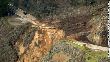
Last week was a rainy one across much of California. Dry weather that ran through December and most of January finally broke. And break it did, with a veritable "Atmospheric River" dumping precipitation across the state. When heavy rain follows an extended dry period it creates risk of mud slides as parched ground is not as able to absorb the rain as well. The risk is especially severe in areas that have experienced wildfire recently. Fire kills the grasses, shrubs, and trees whose roots help hold the soil together; moreover it scorches the ground itself making it even more unable to absorb water.

All of these factors came together last week along California's remote central coast. Water gushing down a rain-swollen creek overwhelmed the land around it and washed away a section of California Highway.


Example coverage: CNN.com article, 30 Jan 2021 tells the basics; San Francisco Chronicle article 29 Jan 2021 has great, high-resolution pictures plus an explainer about what an "Atmospheric River" is.

Landslides are not uncommon on California's rugged Central Coast. In 2017 a massive slide covered almost a half mile of the road. Repairs were completed in 2018, routing the road around the new coastline. Just driving on Highway 1 you can see evidence in the roadway of numerous repairs to fix slides and washout damage. Because of the history of slides authorities closed the road to thru traffic last week— thus nobody was injured when a large section of road went crashing into the ocean.

BTW, why does anyone care about a narrow road in a remote place? Well, aside from the tiny number of people for whom it's the only way in or out of the places they live and work, the Central Coast is an amazing scenic tourist area. Check out some of my roadside pictures from a road trip in 2019 here and here.

canyonwalker: Uh-oh, physics (Wile E. Coyote)
I've written twice in the past month about how it's been a dry winter so far in California. In my late December entry I explained why rain is seasonal and why winter rain is important. Well, I asked for rain... and now we're getting it. ...And not just rain but a figurative river in the sky, an "Atmospheric River", as CBS News Bay Area reported (28 Jan 2021).

Rain poured on Sunday, then again on Tuesday, and then again overnight and into this morning. We've tallied probably a few inches around my home in the past several days. What's falling as rain here is snow up in the Sierras. At high elevations they've gotten several feet already this week, with estimates up to 10 feet (3 meters) by Friday. Back down here in the valley the rain hasn't reached a point of deluge... yet. Localized flooding could come.

Over in the Santa Cruz Mountains, southwest of here between us and the Pacific Ocean, flooding and mudslides already are a real risk. That's especially true in areas burned in lightning-strike fires last August/September. Fire kills vegetation; when it rains heavily after that there's less to hold the ground together so mudslides become a danger. Moreover, fire scorches bare earth so that even if is less able to absorb rain, further raising the risks of flooding and mudslides.

Does this mean no drought, at least? Haha, no. We still need more rain to catch up to normal for the year, let alone to catch up to normal for last year & this one averaged together. We just need gradual rain!

Profile

canyonwalker: wiseguy (Default)
canyonwalker

May 2025

S M T W T F S
     1 2 3
4 5 6 7 8 9 10
11 12 13 14 15 16 17
18 19 20 21 22 23 24
25 26 27 28 29 3031

Syndicate

RSS Atom

Most Popular Tags

Style Credit

Expand Cut Tags

No cut tags
Page generated May. 30th, 2025 11:32 pm
Powered by Dreamwidth Studios