canyonwalker: My other car is a pair of hiking boots (in beauty I walk)
On our hike at Devil's Slide last weekend we did more than marvel at the landscape. I noted that as amazing as this (old) stretch of road was when it was Highway 1, it's even more amazing now as a hiking/biking trail. That's because taking it slower than 35pmh, much slower, provides time to see things we'd miss from inside a car. For example, there were wildflowers; you saw some of those in my two previous blogs on this trip. But there were also birds and battlements.

Ravens grooming at Devil's Slide (Feb 2022)

One of the things we were able to see at walking speed was this pair of ravens perched just a few steps from the edge of a 200+ foot cliff. They're kind of playful. One is pecking at the other with its beak.

Ravens grooming at Devil's Slide (Feb 2022)

Except it's not exactly pecking. I believe it's grooming, picking small bits of debris out of another's feathers. It's a form of affection. The birds are likely a mated pair and they're doing the raven equivalent of holding hands on a nice day on the coast.

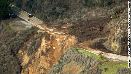
By the way, when I say they're just a few steps from the edge of a cliff, I mean this:

Egg Rock at Devil's Slide (Feb 2022)

The birds were on the shoulder of the road you see in the upper left of the frame. This is a picture I took a few minutes before we saw the birds. The condition of the cliff immediately below the road is testament to why this is called Devil's Slide and why Highway 1 has been rerouted through a tunnel.

BTW, the grass covered granite knob in the center of the picture is called Egg Rock. You may notice a trail diagonalling up from the road to the top of the rock. That's actually an old, narrow paved road. At the top, under than small stand of trees, is a WWII battlement. The government built fortified gun batteries along the coast around San Francisco to watch for, and begin the fight back against, enemy assault. As with other batteries in the area, the guns were never fired in anger.

The well disguised battlement atop Egg Rock isn't the only one in the immediate area. Less than a mile south there's a fairly obvious one sitting another another knob:

Battlement atop a bluff near Devil's Slide (Feb 2022)

This one's open to the public... or what's left of it is, anyway. Our friend Devlin remarked that there used to be sign at the edge of the road. "What did it say?" I asked. "NO PARKING FOR AXIS POWERS?" 🤣

Battlement atop a bluff near Devil's Slide (Feb 2022)

We walked around the old fortification atop the cliff without going in. There is a path to scramble up into the concrete bunker around the right in the back. There's really nothing inside, though, except the reek of piss and weed. There are so many nicer things here; basically all the views.

Hiking at Devil's Slide (Feb 2022)


canyonwalker: My other car is a pair of hiking boots (in beauty I walk)
I already wrote a bit about our visit to Devil's Slide on Saturday. Here's more detail— with pictures— about our hike, the old Highway 1, and why traffic now flows through a tunnel.

California's Highway 1, called in some places the Pacific Coast Highway, was an ambitious public engineering feat completed in the 1930s. It traversed rugged terrain to connect cities and towns on the coast. It was not only utilitarian but jaw-droppingly beautiful. Highway 1 is widely cited as one of the top scenic drives in the US.

Old Hwy 1 at Devil's Slide is now a hiking/biking path (Feb 2022)

Devil's Slide, about 10 miles of San Francisco, is one of many stretches of Highway 1 where the road hugs the coastal mountainside. From the shoulder of the road it's 200' or more down to the pounding surf of the Pacific Ocean below.

In this picture (above) you can see the original route of Highway 1 as it was completed in 1936. The road edges around the flank of San Pedro Mountain.

...Well, not the original route. The road was rebuilt in 1940 after a major landslide wiped out a lot of this section. Landslides happened several more times after that. My recollection from living in the SF Bay Area in the 1990s and 2000s was that every rainy season here was at least one alert on the radio, "Highway 1 is closed at Devil's Slide...." Some of these minor closures to clean up debris on the roadway. Other closures lasted days or weeks to dig out the road and shore up its foundation.

Why landslides here?

Sandstone cliffs make Devil's Slide prone to landslides (Feb 2022)

Landslides happen frequently at Devil's Slide— and hence its name— because San Pedro Mountain has a lot of sandstone as its top layers. You can see the layers of sandstone in the second picture, above. Sandstone erodes easily, so the action of waves and wind and rain eat away at it. Other mountains in the area are made of granite and don't have this weakness.

As early as the 1950s local activists advocated for rerouting Highway 1 through a tunnel under the San Pedro Mountain. This was deemed more feasible than routing over the mountain due to its steepness and environmental sensitivity. The state and county finally agreed in the 1990s, and in 2005 construction of twin tunnels, 1.2km long, began. When the tunnels opened in 2013 a 1.3 mile stretch of the old road was blocked off to vehicle traffic and made a hiking/biking trail. There are small parking lots at each end. The south end even has a bus stop.

Devil's Slide. Old Hwy 1 snakes around the right. (Feb 2022)

As glorious a driving route as Highway 1 is, the Devil's Slide area is even better as a hiking/biking route.

Update: keep reading about Devil's Slide with part 2: Birds and Battlements!

canyonwalker: My other car is a pair of hiking boots (in beauty I walk)
Saturday we met up with our friends David and Devlin in Pacifica. Our stated goal was to go on a hike, an activity we've shared together a few times since the start of the pandemic. For the hike we agreed on Devil's Slide, an area just a little south of Pacifica.

Devil's Slide is a precarious cliff-side route that California's famous Highway 1 used to follow. The area was prone to slides that frequently closed the road (hence its name). Several years ago the state completed a tunnel bypass through the mountain for Highway 1. Now the old road bed is a trail for hikers, joggers, and cyclists.

Hiking with friends at Devil's Slide (Feb 2022)

I'll write more about the trail and the history of the area in another blog soon. For now I'll just share this picture of us— well, David, Devlin, and Hawk; I'm taking the picture— atop one of the cliffs.

At first we thought our hike would be about 2.6 miles, and our friends weren't sure if they could do all of it. Well, we got to the end of the trail (it's an out-and-back proposition) and everyone was feeling fine, so we decided to extend our trek. We hiked to another cliff where there was a historical WWII fortification. That extended our trip to nearly 4 miles all-in.

After the hike Devlin suggested we drive a bit further south to a great walk-up fish restaurant in Pillar Point. We piled into our convertible for the ~10 minute drive.

Yes, we fit 4 adults in our BMW 230i convertible! That's the first time we've even tried to do that since... ever... in this car, or its predecessor, or its grand-predecessor. The back seat accommodations were... cozy... for the two adults back there, but it all worked. And everyone enjoyed driving top-down in the phenomenal weather.

Takeaway window at Barbara's Fishtrap in Pillar Point (Feb 2022)

Speaking of phenomenal weather, lots of other people apparently had the same idea as we did on Saturday: do some outdoorsy stuff on the coast around mid-day, enjoying the sun and low-60s (16-17° C) weather, then stop by the Fishtrap for some freshly cooked seafood. Even the takeaway window had a line about 20 people deep.

Outdoor dining at Barbara's Fishtrap in Pillar Point (Feb 2022)

We took turns between waiting in line and waiting at one of the outdoors tables. This picture (above) makes it look like we're just sitting next to a parking lot. The views are actually way more expansive. Beyond that lot is the town's marina; off to the right is a sandy bay. Behind the camera are coastal mountains. It was a beautiful way to top off a day outdoors.

After this late afternoon snack / early dinner we dropped David and Devlin off at their house and drove home ourselves. Devlin told us he and David fell asleep for naps pretty much right away. It wasn't even 5pm! Naptime wouldn't come that quickly for us. Our drive home was over an hour. W took a scenic route through Half Moon Bay to enjoy sunset over the coast. Then we stopped at a favorite donut shop near home for dessert.

canyonwalker: My other car is a pair of hiking boots (in beauty I walk)
Our return trip to Garrapata State Park last weekend didn't end with our hike around the Whale Peak loop. Actually, our trip to that park did, but not our day trip to the Central Coast. After returning to the car we continued further south, stopping for lunch at a busy food counter that's 87 years old. You might think, "Pfft. 87 years old, that's nothing."  But that's about as old as modern human development gets in this remote area. This beautiful but rugged coastal mountain geography was almost impassible until Highway 1 was built in the 1930s.

Heading south wasn't about getting lunch, though. It was about making a longer day of our day trip and hoping the weather might improve. Alas, the weather didn't improve, but we tried to make the best of it by driving down to Julia Pfeiffer Burns state park for a short visit. You know, the home of McWay Falls. Okay, both of those names are unfamiliar? Well, maybe you've seen it in a book, pamphlet or blog about California scenery, a calendar of California waterfalls, or on the cover of National Geographic.

McWay Falls, Julia Pfeiffer Burns State Park, California [Aug 2021]

That's McWay Falls. In obscure, little Julia Pfeiffer Burns state park. On the rugged central coast area of California that few people were able to get to until Highway 1 was built here in 1932.

And I didn't even go in the park to take that picture. I took it from the side of Highway 1. Cars were driving past me 2 meters away. Highway 1 along the central coast is routinely listed as one of the top scenic drives in the US. With views like this you can see why.

We didn't just marvel at the falls from the side of the road, though. We walked into the park and along a short trail there. We could do that because the park was open! It had been closed for several years after a flood wiped out many trails in the park.

McWay Falls, Julia Pfeiffer Burns State Park, California [Aug 2021]

Only part of the park is open even now. Most of the trails are still closed due to damage that hasn't been fixed, and even the McWay Falls trail is only open to about half its previous length. We walked as far as was safe. A big chain-link gate blocked the trail past that point.

In case you're wondering why the perspective on McWay Falls looks nearly the same between the outside and inside-the-park pictures, modulo zoom and cropping, it's because the trail in the park actually isn't that far away from the roadside. It's maybe 15 meters down the cliff. For reference, the falls is about 25 meters (about 80') tall.

What else is different about the photos? Well, with the second one I had fun experimenting with my variable neutral density filter again. Yeah, that's the one I've written about using at Bassi Falls and Elk Creek Falls. Reducing the light into the camera let me shoot at a slow shutter speed, about 0.14s, that blurs moving things such as water. I forgot to take my tripod with me on this trek (a tripod is helpful for stabilizing the camera when shooting slow exposures) so I braced it against that aforementioned chain link fence. It's safety and photography! 😂

canyonwalker: Sullivan, a male golden eagle at UC Davis Raptor Center (Golden Eagle)
Last week was a rainy one across much of California. Dry weather that ran through December and most of January finally broke. And break it did, with a veritable "Atmospheric River" dumping precipitation across the state. When heavy rain follows an extended dry period it creates risk of mud slides as parched ground is not as able to absorb the rain as well. The risk is especially severe in areas that have experienced wildfire recently. Fire kills the grasses, shrubs, and trees whose roots help hold the soil together; moreover it scorches the ground itself making it even more unable to absorb water.

All of these factors came together last week along California's remote central coast. Water gushing down a rain-swollen creek overwhelmed the land around it and washed away a section of California Highway.


Example coverage: CNN.com article, 30 Jan 2021 tells the basics; San Francisco Chronicle article 29 Jan 2021 has great, high-resolution pictures plus an explainer about what an "Atmospheric River" is.

Landslides are not uncommon on California's rugged Central Coast. In 2017 a massive slide covered almost a half mile of the road. Repairs were completed in 2018, routing the road around the new coastline. Just driving on Highway 1 you can see evidence in the roadway of numerous repairs to fix slides and washout damage. Because of the history of slides authorities closed the road to thru traffic last week— thus nobody was injured when a large section of road went crashing into the ocean.

BTW, why does anyone care about a narrow road in a remote place? Well, aside from the tiny number of people for whom it's the only way in or out of the places they live and work, the Central Coast is an amazing scenic tourist area. Check out some of my roadside pictures from a road trip in 2019 here and here.

Profile

canyonwalker: wiseguy (Default)
canyonwalker

May 2025

S M T W T F S
     1 2 3
4 5 6 7 8 9 10
11 12 13 14 15 16 17
18 19 20 21 22 23 24
25262728293031

Syndicate

RSS Atom

Most Popular Tags

Style Credit

Expand Cut Tags

No cut tags
Page generated May. 25th, 2025 11:53 pm
Powered by Dreamwidth Studios